|
- Updated to: July 7, 2004 -
(Includes
Amendments Approved June 22, 2004)
(Click
HERE
for Previous Version of this Regulation)
CHAPTER L-5
PRINCE EDWARD ISLAND LANDS PROTECTION ACT
EXEMPTION REGULATIONS
|
|
|
Pursuant to section 17(1)(b) of the
Prince Edward Island
Lands Protection Act
R.S.P.E.I. 1988, Cap. L-5, Council made the following
regulations:
|
|
Exemption
|
1. Persons
who acquire a land holding by gift, devise or inheritance from a spouse,
sibling or direct descendant or ancestor are exempt from the application of
section 4 of the Act.
(EC368/88)
|
|
Acquisitions by East Isle Shipyard Limited
|
2. (1) The interests in land (9.5 acres) and
waterlots (7.56 acres) acquired by East Isle Shipyard Limited from Georgetown Shipyard
Inc.
|
|
|
(i) by lease dated September 30, 1991, |
| |
|
(ii) by option dated April 30, 1993, and |
| |
|
(iii) by deed dated May 2, 1994
|
|
|
are exempt from the application of the Act.
|
|
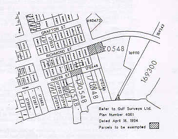
Conveyance to East Isle Shipyard Limited
|
(2) The acquisition by East Isle Shipyard Limited
by Deed of Conveyance of four land holdings in the Town of Georgetown as illustrated in
Schedule 1 is exempt from the application of the Act.
|
|
Condition
|
(3) Subsections (1) and (2) will cease to have effect if the property is used for
any purpose other than
|
| |
|
(a) the purposes referred to in clauses 7(a), (b) and (c) of the Georgetown
Shipyard Act R.S.P.E.I. 1988, Cap. G-4; or |
| |
|
(b) another purpose approved by the Minister of Community
and Cultural Affairs.
(EC566/91; 639/93; 221/94; 230/94; 2000/699, eff. May
1, 2000))
|
|
Conveyance to Irving Pulp and Paper Limited
|
3. The property identified by provincial parcel
identification number 75325 comprising approximately forty-two (42) acres of land located
at Clermont in Prince County, to be acquired by Irving Pulp and Paper Limited by Deed of
Conveyance, and to be used
|
|
|
(a) as part of or in conjunction with an environmental waste
treatment facility; |
| |
|
(b) as part of or in conjunction with a potato processing facility; or |
| |
|
(c) for any other purpose approved by the Lieutenant Governor in
Council,
|
|
|
is exempt from
the application of the Act.
(EC266/92)
|
|
Interests acquired
|
4. The
acquisition by the Community Hospital O'Leary of approximately four decimal
eight three (4.83) hectares of land in O'Leary, Prince Edward Island is
exempt from the application of section 5 of the Act, provided that the said
land is used as the site of the new Community Hospital.
(EC294/92)
|
|
Strait Crossing
|
5. (1) The following interests
to be acquired by Strait Crossing Development Inc., a body corporate duly incorporated
under the laws of the Province of Ontario and duly licensed to do business in the Province
of Prince Edward Island, are exempt from the application of the Act:
|
| |
|
(a) Interests
to be acquired by Deed of Conveyance from John L. Read
|
| |
|
|
(i) parcel no. 380451, located at Borden, Lot 28,
Prince County and containing approximately 86.12 acres (34.87 hectares), |
| |
|
|
(ii) parcel no. 380469, located at Borden, Lot 28, Prince County and
containing approximately 40 acres (16.19 hectares), |
| |
|
|
(iii) parcel no. 380436, located at Borden, Lot 28, Prince County and
containing approximately 6.00 acres (2.43 hectares), |
| |
|
|
(iv) parcel no. 380444, located at Borden, Lot 28, Prince County and
containing approximately 10.70 acres (4.33 hectares),
|
| |
|
being in total
approximately 142.82 acres (57.82 hectares);
|
| |
|
(b) Interests to be acquired by Lease from Her
Majesty the Queen in Right of Canada, as represented by the Minister of Supply and
Services and of Public Works, for a lease period extending up to and including October 31,
2032, the following parcels appearing on a Plan of Survey prepared by the Department of
Supply and Services and of Public Works of Canada, Real Estate Division, Halifax, N.S.,
being designated as:
|
| |
|
|
(i) Plan No. S-1875-W entitled "Plan of Survey
Showing Parcels A,B,C,D, 92-A-1, and 92-A-2, Lands of Her Majesty the Queen in Right of
Canada and Parcels E and F, Land and Land Covered by Water Required by Her Majesty the
Queen in Right of Canada at Borden, Lot 28, Prince County, Prince Edward Island",
dated January 20, 1987, revised to July 30, 1993, and filed in the Prince County Registry
Office on September 17, 1993, as Plan #2937,
|
| |
|
|
|
(A) parcel no. 92-A-1 containing approximately 8.69
acres (3.52 hectares), |
| |
|
|
|
(B) parcel no. 92-A-2 containing approximately .76 acres (.30 hectares), and |
| |
|
|
|
(C) parcel "D" containing approximately 51.02 acres
(20.65 hectares),
|
| |
|
being a total of approximately 60.47 acres (24.47 hectares),
|
| |
|
|
(ii) Plan No. S-2801-C entitled, "Plan of Survey
Showing Parcels 92-6,92-6A, 92-6B, 92-6C, 92-7, 92-6D, 92-8, 92-8A, 86-16, 86-17 and
86-18, Lands of Her Majesty the Queen in Right of Canada, NORTHUMBERLAND STRAIT CROSSING,
Lots 27 and 28, Prince County, Prince Edward Island", dated October 19, 1992, revised
to July 30, 1993, and filed in the Prince County Registry Office on September 17, 1993, as
Plan #2940,
|
| |
|
|
|
(A) parcel 92-8 containing approximately 18.76 acres (7.60 hectares), |
| |
|
|
|
(B) parcel 92-6 containing approximately 95.08 acres (38.49 hectares),
|
| |
|
being a total of approximately 113.84 acres (46.09 hectares),
|
| |
|
|
(iii) Plan No. S-3151 entitled "Plan Showing
Proposed Fixed Crossing, New Brunswick - Prince Edward Island", dated July 30, 1993,
and filed in the Prince County Registry Office on September 17, 1993, as Plan #2941,
|
| |
|
|
|
(A) parcel B containing approximately 548.35 acres
(221.915 hectares),
|
| |
|
being a total of approximately 548.35 acres (221.915 hectares);
|
| |
|
(c) Interests to be acquired by License from Her
Majesty the Queen in Right of Canada, as represented by the Minister of Supply and
Services and of Public Works for a license period extending up to and including May 31,
2001, the following parcels appearing on a Plan of Survey prepared by the Department of
Supply and Services and of Public Works of Canada, Real Estate Division, Halifax, N.S.,
being designated as:
|
| |
|
|
(i) Plan No. S-2801 -A entitled "Plan of Survey
Showing Parcels 92-1, 92-2A, 92-2B, 92-3, 92-4, 92-5A and 92-5B, Lands of Her Majesty the
Queen in Right of the Province of Prince Edward Island and Parcel 92-5, Lands of Her
Majesty the Queen in Right of Canada, NORTHUMBERLAND STRAIT CROSSING, Lot 27, Prince
County, Prince Edward Island", dated October 19, 1992, revised to July 30, 1993, and
filed in the Prince County Registry Office on September 17, 1993, as Plan #2938,
|
| |
|
|
|
(A) parcel 92-2A containing approximately 9.86 acres
(3.99 hectares), |
| |
|
|
|
(B) parcel 92-5B containing approximately 5.41 acres (2.19 hectares), |
| |
|
|
|
(C) parcel 92-5A containing approximately 28.02 acres (11.34 hectares), |
| |
|
|
|
(D) parcel 92-2B containing approximately 2.99 acres (1.21 hectares), |
| |
|
|
|
(E) parcel 92-3 containing approximately 5.66 acres (2.29 hectares), and |
| |
|
|
|
(F) parcel 92-1 containing approximately 8.57 acres (3.47 hectares),
|
| |
|
being a total of approximately 60.51 acres (24.49 hectares),
|
| |
|
|
(ii) Plan No. S-2801-A, aforesaid, Plan No. S-2801-C,
aforesaid, and Plan No. S-2801-B, entitled "Plan of Survey Showing Parcels 92-5, 92-6
and 92-6C, Lands of Her Majesty the Queen in Right of Canada, NORTHUMBERLAND STRAIT
CROSSING, Lots 27 and 28, Prince County, Prince Edward Island", dated October 19,
1992, revised to July 30, 1993, and filed in the Prince County Registry Office on
September 17, 1993, as Plan #2939,
|
| |
|
|
|
(A) parcel no. 92-5 containing approximately 304.10
acres (123.07 hectares),
|
| |
|
being a total of approximately 304.10 acres (123.07 hectares),
|
| |
|
|
(iii) Plan No. A1-01-9-AR-001, entitled "PEI
Approach Roadways Functional Design and Property Requirements, Issue: Closing Project
Design" dated June 14, 1993, and filed in the Prince County Registry Office on
September 17, 1993, as Plan #2942,
|
| |
|
|
|
(A) parcel containing approximately 16.53 acres (6.69
hectares) of land located adjacent to the northeast boundary of the proposed Seven Mile
Bay Road interchange, |
| |
|
|
|
(B) parcel containing approximately .67 acres (.27 hectares) of land
located adjacent to the northwest boundary of the proposed Seven Mile Bay Road
interchange, |
| |
|
|
|
(C) parcel containing approximately 9.32 acres (3.77 hectares) of land
located adjacent to the southwest boundary of the proposed Seven Mile Bay Road
interchange, |
| |
|
|
|
(D) parcel containing approximately 7.31 acres (2.96 hectares) of land
located adjacent to the southerly boundary of the Albany Road interchange,
|
| |
|
being a total of approximately 33.83 acres (13.69 hectares),
|
| |
all of which land referred to in this subsection totals approximately
1264 acres (512 hectares).
|
|
Condition |
(2) Subsection (1) will cease to
have effect if the property is used for any purpose other than
|
| |
|
(a) as part of, or in conjunction with, the
construction and operation of the Fixed Link and ancillary and related facilities; or |
| |
|
(b) another purpose approved by the Minister of Community
and Cultural Affairs.
(EC474/93; EC699/00)
|
|
Exemption
|
6. The following interest to be
acquired by Strait Crossing Development Inc., a body corporate duly incorporated under the
laws of the Province of Ontario and duly licensed to do business in the Province of Prince
Edward Island, is exempt from the application of the Act.
|
|
|
An interest to be acquired from the Government of Prince Edward Island
as represented by the Minister of Transportation and Public Works of Crown lands and lands
covered by water at Carleton Siding, Lot 28 in Prince County being in total approximately
7.3 hectares being more particularly described as follows:
|
|
|
ALL THAT PARCEL OF LAND COVERED BY WATER situate, lying and being at
Carleton Siding, lot or township no. 28, in Prince County, Province of Prince Edward
Island, bounded and described as follows that is to say:
|
|
|
COMMENCING at a calculated point set along the ordinary high water
mark, as shown on a survey plan entitled; "Plan of Survey Showing Waterlot
"A-94" Being a Portion of Lands and Water Above Lands of the Northumberland
Strait" as prepared by Locus Surveys Ltd. and Certified by K.C. Brown P.E.I.L.S. on
June 21, 1994 as drawing no. 93504A, said point being designated by calculated point no.
1163, and having coordinates Easting 447118.7701 metres and Northing 5121451.4823 metres;
|
|
|
THENCE in a southeasterly direction along the ordinary high water mark,
as shown on the above mentioned plan for the distance of 160.5 metres a little more or
less to calculated point no. 1160, having coordinates Easting 447197.7563 metres and
Northing 5121311.6936 metres;
|
|
|
THENCE on an azimuth of 235o 44'34" for a distance of
450.000 metres to calculated point no. 1161, having coordinates Easting 446825.8234 metres
and Northing 5121058.3838 metres;
|
|
|
THENCE on an azimuth of 325o 44'34" for a distance of
160.000 metres to calculated point no. 1162, having coordinates Easting 446735.7577 metres
and Northing 5121190.6266 metres;
|
|
|
THENCE on an azimuth of 55o 44'34" for a distance of
463.405 metres to the point at the place of commencement.
|
|
|
Containing an area of 7.30 hectares (18.04 acres) a little more or less
of land and land covered by water and being Parcel "A-94" on the above mentioned
plan.
|
|
|
All azimuths are north grid azimuths, all grid azimuths and coordinates
are referenced to the North American Datum - 83 utilizing Universal Transverse Mercator
Projection. All coordinates are expressed in metres.
(EC372/95)
|
|
Idem
|
7. The following interest to
be acquired by Strait Crossing Development Inc., a body corporate, duly incorporated under
the laws of the Province of Ontario and duly licensed to do business in the Province of
Prince Edward Island, is exempt from the application of the Act:
|
|
|
An interest to
be acquired by lease from the Unit Two School Board of land in the Town of
Borden, Lot 28, Prince County, Prince Edward Island being in total
approximately 0.59 hectares (1.46 acres) being more particularly described
as follows:
|
| |
|
COMMENCING at
a point located in the northeast corner of the Old Borden School property as
shown on plan of survey entitled "Old Borden School" as prepared by Carl G.
MacDonald, P.E.I.L.S. in September 1992 as drawing no. 2105, said
point being designated by calculated station no. 8 on said plan and having
coordinates east 246545.424, north 189288.282;
|
| |
|
THENCE on an azimuth of 165o01'22" for a distance of
39.624 metres to calculated station no. 9 on said plan having coordinates east 246555.664,
north 189250.004;
|
| |
|
THENCE on an azimuth of 255o03'19" for a distance of
62.179 metres to calculated station no. 13 on said plan having coordinates east
246495.588, north 189233.968;
|
| |
|
THENCE on an azimuth of 345o01'22" for a distance of
1.463 metres to calculated station no. 14 on said plan having coordinates east 246495.210,
north 189235.382;
|
| |
|
THENCE on an azimuth of 255o03'19" for a distance of
90.250 metres to calculated station no. 6 on said plan having, coordinates east
246408.013, north 189212.107;
|
| |
|
THENCE on an azimuth of 345o15'59" for a distance of
38.161 metres to calculated station no. 5 on said plan having coordinates east 246398.308,
north 189249.014;
|
| |
|
THENCE on an azimuth of 75o03'19" for a distance of
152.266 metres to point at place of commencement.
|
| |
|
BEING AND
INTENDED to be Parcel "A" on the aforementioned plan and having an area of
0.59 hectares (1.46 acres) of land.
(EC123/94)
|
|
Idem
|
8. (1) The following interests to be
acquired by Central Kings Development Corporation, a division of Irving Pulp and Paper
Ltd. Cavendish Farms - Les Fermes Cavendish, and Malpeque-Westisle Fertilizers Limited are
exempt from the application of the Act:
|
Central Kings
Development Corporation
|
|
(a) an interest to be acquired through purchase by Central Kings
Development Corporation of approximately 98 acres of land in Lot 52, Kings County, Prince
Edward Island;
|
|
Cavendish Farms
|
|
(b) an interest to be acquired through lease by
A Division of
Irving Pulp and Paper Ltd. Cavendish Farms - Les Fermes Cavendish of approximately 98
acres of land in Lot 52, Kings County, Prince Edward Island; and
|
Malpeque-Westisle Fertilizers Limited
|
|
(b. 1) an interest to be acquired through mortgage by
Malpeque-Westisle Fertilizers Limited of approximately 98 acres of land in Lot 52, Kings
Country, Prince Edward Island;
|
Malpeque-Westisle Fertilizers Limited
|
|
(c) an interest to be acquired through purchase by
Malpeque-Westisle Fertilizers Limited of approximately 98 acres of land in Lot 52, Kings
Country, Prince Edward Island;
|
Malpeque-Westisle Fertilizers Limited
|
|
(d) an interest to be acquired by Malpeque-Westisle Fertilizers
Limited in approximately 98 acres of land in Lot 52, Kings County, Prince Edward Island by
way of assignment of leasehold interest from Cavendish Farms - Les Fermes Cavendish, a
division of Irving Pulp and Paper Ltd.
|
Description
|
(2) The said lands are described as follows:
|
| |
PARCEL #1
PROPERTY NO. 551317
|
| |
|
ALL THAT tract or parcel of land situate, lying, and being in Lot or
Township No. 52, in the County of Kings, Province of Prince Edward Island, bounded and
described as follows, that is to say:
|
| |
|
COMMENCING at a point situate on the Northwestern boundary line of a
road leading to St. Peter's known as the Seven Mile Road said point being delineated by
legal survey marker No. 626, as the same is shown on a plan of survey prepared by Locus
Surveys Limited entitled "Plan of Surveys Showing Lands of Neil S. MacDonald" as
Drawing No. 94192-2 dated May 9, 1994, said legal survey marker No. 626 having coordinates
Easting 588782.259 and Northing 323234.532;
|
| |
|
THENCE on an azimuth 341o
17'52" for a distance of 3,050 feet to a point delineated by legal survey
No. 627, said legal survey marker No. 627 having coordinates Easting
587804.280 and Northing 326123.487; |
| |
|
THENCE on an azimuth 71o 17'52" for a distance of
538.18 feet to a point delineated by legal survey marker No. 629 on the said plan; |
| |
|
THENCE on an azimuth 161o 40'46" for a distance of
1,226.96 feet to a point delineated by a calculated point No. 630 on the said plan;
|
| |
|
THENCE on an azimuth 161o 20'12" for a distance of
796.70 feet to a point delineated by a calculated point No. 631 on the said plan;
|
| |
|
THENCE on an azimuth 161o 32'04" for a distance of
482.76 feet to a point delineated by a calculated point No. 632 on the said plan;
|
| |
|
THENCE in a Southwesterly direction on the Northwestern boundary line
of the said Seven Mile Road following the curvature of the road having a radius of
2,867.74 feet for an arc distance of 275.03 feet to a point delineated by a calculated
point No. 607 on the said plan;
|
| |
|
THENCE on an azimuth 294o 59'24" for a distance of
149.99 feet to a point delineated by legal survey marker No. 608 on the said plan;
|
| |
|
THENCE on an azimuth 204o 59'24" for a distance of
100.22 feet to a point delineated by legal survey marker No. 609 on the said plan;
|
| |
|
THENCE on an azimuth 114o 59'24" for a distance of 150
feet to a point delineated by legal survey marker No. 606 as shown on said plan;
|
| |
|
THENCE on an azimuth 204o 20'46" for a distance of
380.65 feet to a point delineated by legal survey marker No. 626 as shown on said plan;
|
| |
|
THE ABOVE DESCRIBED parcel of land containing 34.18 acres of land, a
little more or less.
|
| |
|
SUBJECT to a 40' wide right-of-way along the Eastern boundary of the
above-described parcel of land.
|
| |
PARCEL#2
PROPERTY NO. 429803
|
| |
|
ALSO ALL THAT other parcel of land situate, lying and being in Lot or
Township No. 52, in Kings County, in the Province of Prince Edward Island, bounded and
described as follows:
|
| |
|
COMMENCING on the Northwestern boundary line of a road commonly known
as the Seven Mile Road, said point being delineated by legal survey marker No. 601, as the
same is shown on a Plan of Survey prepared by Locus Surveys Limited entitled "Plan of
Survey Showing Lands of Neil S. MacDonald" being Drawing No. 94192 dated May 2, 1994,
said legal survey marker No. 601 having coordinates Easting 588539.410 and Northing
322697.830;
|
| |
|
THENCE on an azimuth 341o 22'02" for a distance of
415.40 feet to a point delineated by legal survey marker No. 597 on the said plan;
|
| |
|
THENCE on an
azimuth 253o 30'38" for a distance of 183.39 feet to a point
delineated by calculated point No. 618 on the said plan;
|
| |
|
THENCE on an azimuth 249o 54'51" for a distance of
205.68 feet to a point delineated by legal survey marker No. 619 on the said plan;
|
| |
|
THENCE on an azimuth 341o 03'12" for a distance of
384.41 feet to a point delineated by calculated point No. 620 on the said plan;
|
| |
|
THENCE on an azimuth 341o 43'19" for a distance of
819.04 feet to a point delineated by calculated point No. 621 on the said plan;
|
| |
|
THENCE on an azimuth 341o 05'11" for a distance of
718.84 feet to a point delineated by calculated point No. 622 on the said plan;
|
| |
|
THENCE on an azimuth 341o 32'14" for a distance of
1,140.72 feet to a point delineated by legal survey marker No. 628 on the said plan;
|
| |
|
THENCE on an azimuth 71o 17'52" for a distance of
783.96 feet to a point delineated by legal survey marker No. 627 on the said plan;
|
| |
|
THENCE on an azimuth 161o 17'52" for a distance of
3,050 feet to a point delineated by legal survey marker No. 626 on the said plan;
|
| |
|
THENCE on an azimuth 204o 20'46" for a distance of
589.09 feet to a point delineated by legal survey marker No. 601 on the said plan; and
being the point at the place of commencement.
|
| |
|
THE ABOVE DESCRIBED parcel of land containing 57.25 acres of land, a
little more or less.
|
| |
PARCEL#3
PROPERTY NO. 749929
|
| |
|
ALSO ALL THAT other parcel of land situate, lying and being on Lot or
Township No. 52, in Kings County, Province of Prince Edward Island, bounded and described
as follows, that is to say:
|
| |
|
COMMENCING at a survey marker set on the Western boundary of P.E.I. Highway No. 4 leading from Pooles Corner to Cardigan, said survey marker being designated
as No. 12 on a plan of survey of lands to be conveyed to Nancy Nabuurs & Ron MacKinnon
as prepared by Norman F. Stewart, dated July 27, 1988, and bearing Drawing No. 88-57. Said
survey marker No. 12 having the Co-ordinates E. 588939.18 and N. 323581.33;
|
| |
|
THENCE Northwestwardly on an azimuth of 294o 59'24" for the distance of
150 feet to a survey marker designated as No. 15 on said plan and having the co-ordinates
E. 588803.22 and N. 323644.70;
|
| |
|
THENCE Northeastwardly on an azimuth of 24o 59'24" for the distance of
100.22 feet to a survey marker designated as No. 14 on said plan and having the
co-ordinates E. 588845.56 and N. 323735.54;
|
| |
|
THENCE Southeastwardly on an azimuth of 114o 59'24" for the distance of
150 feet to a survey marker set on the Western boundary of the aforesaid Highway No. 4,
said survey marker being designated as No. 13 on said plan and having the co-ordinates E.
588981.51 and N. 323672.17;
|
| |
|
THENCE Southwestwardly on an azimuth of 204o 59' 24" along the Western boundary of
the aforesaid Highway No. 4 for the distance of 100.22 feet or to the survey marker set at
the place of commencement.
|
| |
|
CONTAINING
15,0333 square feet of land, a little more or less.
(EC381/94; 487/94;
416/95; 482/95)
|
|
Mortgage |
9. Revoked by EC487/94.
|
Malpeque-Westisle Fertilizers Limited
|
10. (1) The acquisition by Malpeque-Westisle
Fertilizers Limited of approximately two decimal seven five (2.75) acres of land at
Travellers Rest, Lot 19, Prince County adjacent to its existing industrial operation to be
used for construction of a storage facility is exempt from the application of the Act.
|
Description
|
(2) The said lands are described as follows:
|
| |
|
ALL THAT tract, piece or parcel of land situate, lying and being at Travellers Rest,
Lot or Township No. 19, in Prince County, in the Province of Prince Edward Island, bounded
and described as follows, that is to say:
|
| |
|
COMMENCING at a legal survey marker set in the western side of Route 1A
as the same is shown on a plan of survey prepared by Locus Surveys Ltd. entitled
"Plan of Survey Showing Parcel "C" the subdivision of lands of Bradford and
Benjamin Cairns" dated January 10, 1994, and having Drawing No. 93-829, the said
legal survey marker being identified as No. 3567 on the aforementioned plan and having
coordinates East 312920.039 feet and North 394118.896 feet;
|
| |
|
THENCE on an azimuth 204o 15'37" following the western
boundary of Route A to a legal survey marker identified as No. 3580 on the aforementioned
plan;
|
| |
|
THENCE on an azimuth 275o 01'43" a distance of 357.22
feet to a legal survey marker identified as No. 3582 on the aforementioned plan;
|
| |
|
THENCE on an azimuth 359o 02'35" a distance of 451.09
feet to a legal survey marker set in the southern side of the Canadian National Railway
right-of-way as shown on said plan;
|
| |
|
THENCE on an azimuth 75o 43'53" along the C.N.R.
right-of-way to a legal survey marker identified as No. 3573 and being set in the
northwestern corner of property now or formerly owned by Malpeque-Westisle Fertilizers
Ltd.;
|
| |
|
THENCE on an azimuth 179o 02'35" a distance of 265.54
feet to the southwestern angle of the aforesaid Malpeque-Westisle Fertilizers Ltd.
property;
|
| |
|
THENCE on an azimuth 95o 01'43" along the southern
boundary of the Malpeque-Westisle Fertilizers Ltd. property for a distance of 342.50 feet
to the legal survey marker at the point and place of commencement;
|
| |
|
BEING AND
INTENDED to be Parcel "C" as shown on said plan and having a calculated area
of 2.75 acres of land, a little more or less.
(EC572/94)
|
O'Leary Community Health Foundation
|
11. The following interest to be acquired by the
O'Leary Community Health Foundation is exempt from the application of the Act:
|
|
|
an interest to
be acquired through purchase of approximately ten decimal five six (10.56)
acres of land in O'Leary, Lot 6, Prince County.
(EC654/94).
|
Cavendish Farms Foundation, New Annan
|
12. An interest to be acquired through purchase
by Cavendish Farms, a division of Irving Pulp and Paper of approximately 8.0 acres of land
being provincial parcel identification number 75192, located in New Annan,
Prince Edward Island is exempt from the application of the Act.
(EC601/95)
|
Irving Pulp and Paper Limited, New Annan
|
12.1 The interest to be acquired through
purchase by Irving Pulp & Paper, Limited from Island Holdings Ltd. (a wholly owned
subsidiary) of approximately one hundred and eight decimal three two (108.32) acres of
land, being provincial parcel identification numbers 599928 and 75184, located at New
Annan, Prince Edward Island, is exempt from the application of section 5 of
the Act.
(EC758/95)
|
Borden-Carleton box fabrication facility
|
13. The fee simple interest, and any other legal and
equitable interest pertaining thereto, of Provincial Parcel Identification Number 778928,
containing approximately twenty decimal seven six (20.76) acres, located in the Community
of Borden-Carleton, is exempt from the Act with the exception of clause 9(1)(b),
subsection 9(2) and clause 17(1)(d) and the Land Identification Regulations (EC606/95),
subject to the following condition:
|
| |
|
(a) that the
land be used solely for the purpose of a box fabrication facility or another
industrial use acceptable to the Lieutenant Governor in Council; no
commercial agricultural crops shall be grown on the land.
(EC628/95)
|
|
Blueberry processing facility
|
14. The fee simple interest, and any other legal
and equitable interest pertaining thereto, of Provincial Parcel Identification Numbers
177378 and 521518 containing collectively, approximately thirty-nine decimal six four
(39.64) acres, located in Lot 39, Kings County, is exempt from the Act with the exception
of clause 9(1)(b), subsection 9(2) and clause 17(1)(d) and the Land Identification
Regulations (EC606/95), subject to the following condition:
|
| |
|
(a) that the
land be used solely for the purpose of a blueberry processing facility or
another light industrial use acceptable to the Lieutenant Governor in
Council; no commercial agricultural crop shall be grown on the land.
(EC659/95)
|
|
Trigen Energy Canada Inc.
|
15. The interest acquired by Trigen
Energy Canada Inc. through the purchase of land, being Property No. 279000,
containing approximately 3.4 acres on Riverside Drive in Charlottetown,
Queens County, is exempt from the application of section 5 of the Act.
(EC723/95) |
|
McCain Fertilizers
|
16. An
interest to be acquired through purchase by McCain Fertilizers Limited of
approximately 4.33 hectares (10.699 acres) of land subdivided from Property
No. 686360, located in Lot 27, Prince County, Prince Edward Island, is
exempt from the application of section 5 of the Act.
(EC847/95)
|
|
McCain Foods
|
17. The
acquisition through purchase by McCain Foods Limited of approximately 6.68
hectares (16.5 acres) of land, identified as Provincial Property No. 772798,
located in Lot 28, Prince County is exempt from the application of section 5
of the Act.
(EC34/96)
|
|
McCain Fertilizers
|
18. An
interest to be acquired through purchase by McCain Fertilizers Limited of
approximately 4.05 hectares (10 acres) of land located in Lot 51, Kings
County and subdivided from Provincial Property No. 159970, and approximately
0.28 hectares (0.69 acres) of land also located in Lot 51, Kings County and
subdivided from Provincial Property No. 484816, is exempt from the
application of section 5 of the Act.
(EC585/96)
|
|
Legacy Hotels, Canadian Pacific Properties Inc.
|
19. The acquisition of the following interests
in land, identified as parcel nos. 335166 and 335281, located in the City of
Charlottetown, Queens County, are exempt from the application of section 5 of the Act:
|
|
|
(a) the acquisition through lease by Legacy Hotels Corporation; |
| |
|
(b) the acquisition of a beneficial interest through purchase by
Canadian Pacific Properties Inc.; |
| |
|
(c) the acquisition of legal title by deed by 3428851 Canada Ltd.; |
| |
|
(d) the
acquisition of a beneficial interest through purchase by Legacy Hotels Real
Estate Invest Trust.
(EC652/97)
|
|
McCain Fertilizers Limited
|
20. An
interest to be acquired through purchase by McCain Fertilizers Limited of
approximately 2.406 hectares (5.945 acres) subdivided from Property No.
37333, located in Lot 5, Prince County, Prince Edward Island is exempt from
the application of section 5 of the Act.
(EC721/97)
|
|
Cavendish Farms, A Division of Irving Pulp and Paper Limited
|
21. The purchase by Cavendish Farms,
A Division
of Irving Pulp and Paper Limited of approximately 0.29 acres of land, being Provincial
Property Number 442756, located at New Annan in Lot 19, Prince County, is
exempt from the application of section 5 of the Act.
(EC5/99)
|
|
Summerside Golf Club Inc.
|
22. (1)
The
following properties, located in the City of Summerside and totalling approximately 148.51
acres, are exempt from the application of the Act:
|
|
|
(a) approximately 1.01 acres, being Provincial
Property Number 649871; |
| |
|
(b) approximately 2.69 acres subdivided from Provincial Property Number
65326; |
| |
|
(c) approximately 134.97 acres subdivided from Provincial Property
Number 65508; |
| |
|
(d) approximately 2.69 acres subdivided from Provincial Property Number
445973; |
| |
|
(e) approximately 1.76 acres subdivided from Provincial Property Number
460576; |
| |
|
(f) approximately 5.39 acres, being a portion of the Duck Pond Road.
|
|
Condition
|
(2) Subsection (1) shall cease to have
effect
|
| |
|
(a) if any part of the property is used for any
purpose other than a golf course; or |
| |
|
(b) if
any of the properties are conveyed by Summerside Golf Club Inc.
|
| |
without the prior approval of
the Lieutenant Governor in Council.
(EC657/99) |
|
J. D. Irving Limited
|
23. (1)
The
following properties being acquired by J. D. Irving Limited, located in
Georgetown Royalty and totalling approximately 105.62 acres, are exempt from the
application of the Act:
|
| |
|
(a) approximately 29.36 acres, being Provincial
Property Number 730036; |
| |
|
(b) approximately 8.00 acres, being Provincial Property Number
730044; |
| |
|
(c) approximately 60.26 acres, being Provincial Property
Number 820258; |
| |
|
(d) approximately 8.00 acres, being Provincial Property Number 878348.
(EC363/00)
|
|
Prohibition
|
(2) No person shall subdivide any of the real properties listed in subsection
(1). (EC363/00)
|
|
Subsection (2) binding
|
(3) The prohibition against subdivision established by subsection (2) is binding
on J.D. Irving Limited and all successors in title.
(EC363/00)
|
| |
SCHEDULE
|
| |
 |
|
Morell Lions
|
24.
The following properties being acquired by the Morell Lions Club Inc., located
in Morell and totalling approximately 13.75 acres, are exempt from the
application of section 5 of the Act; (EC89/04)
|
| |
|
(a) approximately 10.75 acres,
being Provincial Property Number 182956;
(EC89/04) |
| |
|
(b) approximately 3.0 acres,
being portion of Provincial Property Number 618751.
EC89/04) |
|
Property owned |
25.
(1) The following properties being
acquired by Ocean Choice PEI Inc., located in various parts of the province
as indicated and totalling approximately 31.04 acres, are exempt from the
application of section 5of the Act: |
| |
|
(a)
property owned by Polar Foods International Inc. at Beach Point,
approximately 1.9 acres, being Provincial Property Number 291567-000; |
| |
|
(b)
property owned by Polar Foods International Inc. at Gaspereau, |
| |
|
|
(i)
approximately 10.92 acres, being Provincial Property Number 251157-000, |
| |
|
|
(ii)
approximately 0.58 acres, being Provincial Property Number 251124-000, |
| |
|
|
(iii)
approximately 1.01 acres, being Provincial Property Number 643866-000; |
| |
|
(c)
property owned by Polar Foods International Inc. at Souris, |
| |
|
|
(i)
approximately 11.3 acres, being Provincial Property Number 859470-000, |
| |
|
|
(ii)
approximately 1.18 acres, being Provincial Property Number 101741-000, |
| |
|
|
(iii)
approximately 0.50 acres, being Provincial Property Number 101725, and |
| |
|
|
(iv)
approximately 0.39 acres, being Provincial Property Number 102814; |
| |
|
(d)
property owned by Morning Star Fisheries Ltd. at Victoria, approximately
2.32 acres, being Provincial Property Number 403485-000; |
| |
|
(e)
property owned by Polar Foods International Inc. at Red Head Harbour,
Morell, |
| |
|
|
(i)
approximately 0.58 acres, being Provincial Property Number 550236-000, |
| |
|
|
(ii)
approximately 0.05 acres, being Provincial Property Number 487777-000, |
| |
|
|
(iii)
approximately 0.06 acres, being Provincial Property Number 183632-000, |
| |
|
|
(iv)
approximately 0.12 acres, being Provincial Property Number 183657, and |
| |
|
|
(v)
approximately 0.13 acres, being Provincial Property Number 183640-000.
(EC234/04) |
|
Property leased |
(2) The
interests to be acquired by assignments of lease to Ocean Choice PEI Inc. in
the following properties, located in various parts of the province as
indicated and totalling approximately 141.42 acres, are exempt from the
application of section 5 of the Act: |
| |
|
(a)
wharf property leased by Polar Foods International Inc., |
| |
|
|
(i) at
Naufrage Harbour, Monticello, approximately 6.2 acres, being Provincial
Property Number 540641-047, |
| |
|
|
(ii) at
Naufrage Harbour, Monticello, approximately 14.6 acres, being Provincial
Property Number 823368, |
| |
|
|
(iii) at
North Lake Harbour, approximately
17.51 acres, being Provincial Property Number 111336-331 and 111336-343, and
|
| |
|
|
(iv) at
Poplar Grove, approximately 8.75 acres, being Provincial Property Number
454215-131; |
| |
|
(b)
property leased by Wendell Graham Ltd. at Launching, approximately 19.52
acres, being Provincial Property Number 429902-102; |
| |
|
(c)
property leased by Polar Foods International Inc., Ronnie McGrath, and
Babineau Fisheries at Red Head Harbour, Morell, totalling
approximately 17.8 acres, being Provincial Property Numbers 539254-101,
539254-108, 539254-109 and 539254-122; |
| |
|
(d)
property leased by Polar Foods International Inc. at Souris, approximately
55.12 acres, being Provincial Property Number 103630-152; |
| |
|
(e)
property leased by Polar Foods International Inc. at Howard's Cove,
approximately 1.92 acres, being Provincial Property Number 831586.
(EC234/04) |
|
Property owned |
26. (1) An
interest to be acquired through purchase by Ocean Choice PEI Inc. owned by
Babineau Fisheries at Souris of approximately 0.82 acres, being Provincial
Property Number 182246-000, is exempt from the application of section 5 of
the Act. (EC334/04) |
|
Property leased |
(2)
The interests to be acquired by assignments of the lease to Ocean Choice PEI
Inc. in the following properties, located in various parts of the province
as indicated and totalling approximately 6.95 acres, are exempt from the
application of section 5 of the Act: |
| |
|
(a) property leased by
Babineau Fisheries at Souris, approximately 0.17 acres, being Provincial
Property Number 103630-134; |
| |
|
(b) property leased by
Polar Foods International Inc. at St. Peters, approximately 6.2 acres, being
Provincial Property Number 540641-014; |
| |
|
(c) property leased by
Abeqweit Seafoods at Tignish, approximately 0.58 acres, being Provincial
Property Number 531897-101.
(EC334/04) |
|
Lower Montague Property |
|
27. The property
being acquired by the Lower Montague Trailer Park Cooperative Ltd., located
in Lower Montague and totalling 6.5 acres, being a portion of the property
having Provincial Property Number 193490, is exempt from the application of
section 5 of the Act.
(EC353-04) |
|
_______ |